A reader wrote to tell me he/she received division orders for this well:
- 40998, drl/A, Phoenix Operating, Jacobson 19-30-31-1H LLR, Burg, t11/24; cum 70K 3/25, production to date:
| Pool | Date | Days | BBLS Oil | Runs | BBLS Water | MCF Prod | MCF Sold | Vent/Flare |
|---|---|---|---|---|---|---|---|---|
| BAKKEN | 3-2025 | 31 | 19585 | 19678 | 55353 | 22344 | 20448 | 0 |
| BAKKEN | 2-2025 | 23 | 12237 | 11930 | 43934 | 11951 | 10302 | 0 |
| BAKKEN | 1-2025 | 29 | 17584 | 17695 | 62009 | 16417 | 15468 | 0 |
| BAKKEN | 12-2024 | 31 | 19363 | 19327 | 89197 | 33676 | 3244 | 29198 |
| BAKKEN | 11-2024 | 4 | 1354 | 1157 | 13760 | 831 | 0 | 727 |
| BAKKEN | 7-2024 | 0 | 0 | 0 | 0 | 0 | 0 | 0 |
| BAKKEN | 6-2024 | 0 | 0 | 0 | 0 | 0 | 0 | 0 |
The reader does not have minerals in this section where the well is sited -- NENW 19-160-98 (note the township), 310 FNL 2332 FWL.
So, how does the reader fit into this story?
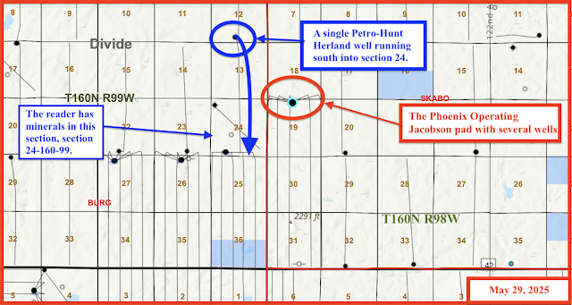
It turns out the reader has minerals in the drilling unit to the west: section 24-160-99 (note the township).
So, how does the reader participate in a well sited to the east, in a completely different township?
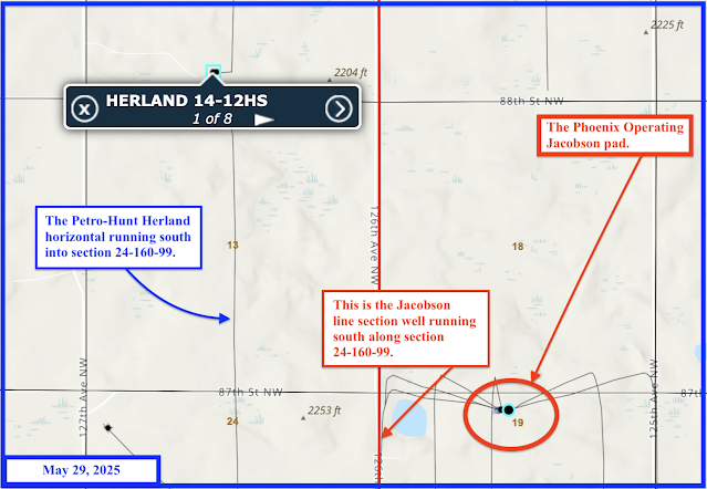
It turns out that the Phoenix Operating Jacobson well is a section line well with takes oil from both sides of the section line including oil from section 24-160-99 where the reader has minerals.
Wow.
The reader has one existing well in this drilling unit and is receiving royalties from that well. Interestingly, that well is a Petro-Hunt well, and not a Phoenix Operating well.
The existing, older Petro-Hunt well is this one:
- 31468, 140, Petro-Hunt, Herland 14-12HS, Burg, t2/16; cum 146K 3/25; sited in SESW 12-160-99, 485 FSL 2300 FWL, and has been producing since February, 2016. The well is a long horizontal and is in a drilling unit consisting of sections 13 and 24 (the reader has minerals in section 24-160-99; recent production:
| Pool | Date | Days | BBLS Oil | Runs | BBLS Water | MCF Prod | MCF Sold | Vent/Flare |
|---|---|---|---|---|---|---|---|---|
| BAKKEN | 3-2025 | 30 | 550 | 485 | 1570 | 644 | 256 | 2 |
| BAKKEN | 2-2025 | 28 | 528 | 475 | 1530 | 571 | 206 | 0 |
| BAKKEN | 1-2025 | 30 | 623 | 705 | 1783 | 635 | 242 | 0 |
| BAKKEN | 12-2024 | 31 | 731 | 727 | 2059 | 671 | 226 | 25 |
| BAKKEN | 11-2024 | 30 | 975 | 962 | 2100 | 735 | 0 | 329 |
| BAKKEN | 10-2024 | 31 | 747 | 705 | 3395 | 585 | 30 | 149 |
So the reader clearly has minerals in section in section 24-160-99, the Petro-Hunt Herland well for which he/she is receiving royalties.
Now, because the Jacobson well is a line section well, she will receive royalties from that one Jacobson well but not from the other Jacobson wells on that pad.
One can stop reading here, but here are the maps.
This is the overview map and may be the most confusing of the maps:
This map zooms in a bit. It shows more closely the relationship between the Phoenix Operating Jacobson line section well and the Petro-Hunt Herland well.
This doesn't show much except the Petro-Hunt Herland well that runs south into section 24-160-99 where the reader has minerals.
This map shows the same thing as the maps above, but zooms in.
A copy of a portion of the deed showing minerals in section 24-160-99. This is from one of "Ruth's" deed deeds.
A copy of a portion of the revenue statement showing the Herland well, from Petro-Hunt:


No comments:
Post a Comment