Sunday, January 30, 2022

Enerplus Acquires Hess Wells In Little Knife Oil Field, Dunn County

Locator: 10010ENERPLUS.

January 30, 2022: Enerplus acquired the Hess wells in Little Knife oil field, Dunn County, announced back on April 8, 2021.

The Hess production page will be updated to show that those wells have been acquired by Enerplus.

The Enerplus page will be updated later to show those new wells for Enerplus. 

One exception: SC-Foster remains with Hess. 

Production, January 29, 2024:

File Number

Full Name


Dec 23

Nov 23

Oct 23


Nov 21

Oct 21

17980

Dukart 3-1H

Enerplus


0

0


214

228

18450

Lind 2-1H

Enerplus


1,149

1,096


624

674

18276

Obrigewitch 4-1H

Enerplus


959

0


430

897

18227

Obrigewitch 34-1H

Enerplus


0

0


643

644

21857

LK-Esther-146-97-3328H-1

Enerplus


944

0


1,316

219

21469

SC-Foster 153-99-2932H-1

Hess


1,281

1,542


1,843

1,363

22799

LK-Dukart 145-97-0310H-2

Enerplus


230

0


1,291

1,125

22802

LK-Dukart 145-97-0310H-3

Enerplus


349

0


650

658

22804

LK-Dukart 145-97-0310H-4

Enerplus


892

236


874

881

22798

LK-Obrigewitch 146-97-3427H-2

Enerplus


588

699


847

1,082

22800

LK-Obrigewitch-146-97-3427H-3

Enerplus


286

0


855

879

22803

LK-Obrigewitch 146-97-3427H-4

Enerplus


985

875


852

1,094

37452

LK-Hamilton-LW-146-97-3526H-1


PNC


LOC

LOC


Total


7,663


10,439

9,744

Saturday, January 22, 2022

Petro-Hunt, #38359 -- Charlson -- January 22, 2022

Locator: 38359B.

Updates

June 7, 2023: today's daily activity report -- this permit has been renewed.

Original Post

Reader can't forget this one.

Petro-Hunt well, #38359, is one of four wells on a four-well pad. Three of the four wells are producing. This fourth well, #38359, is still on confidential line, and not producing. 

The reader must not forget this well.

Monday, January 10, 2022

Tucker Well -- #37452 -- A Line Section Well -- Little Knife -- Dunn County -- Section 34-146-97 -- January 10, 2022-

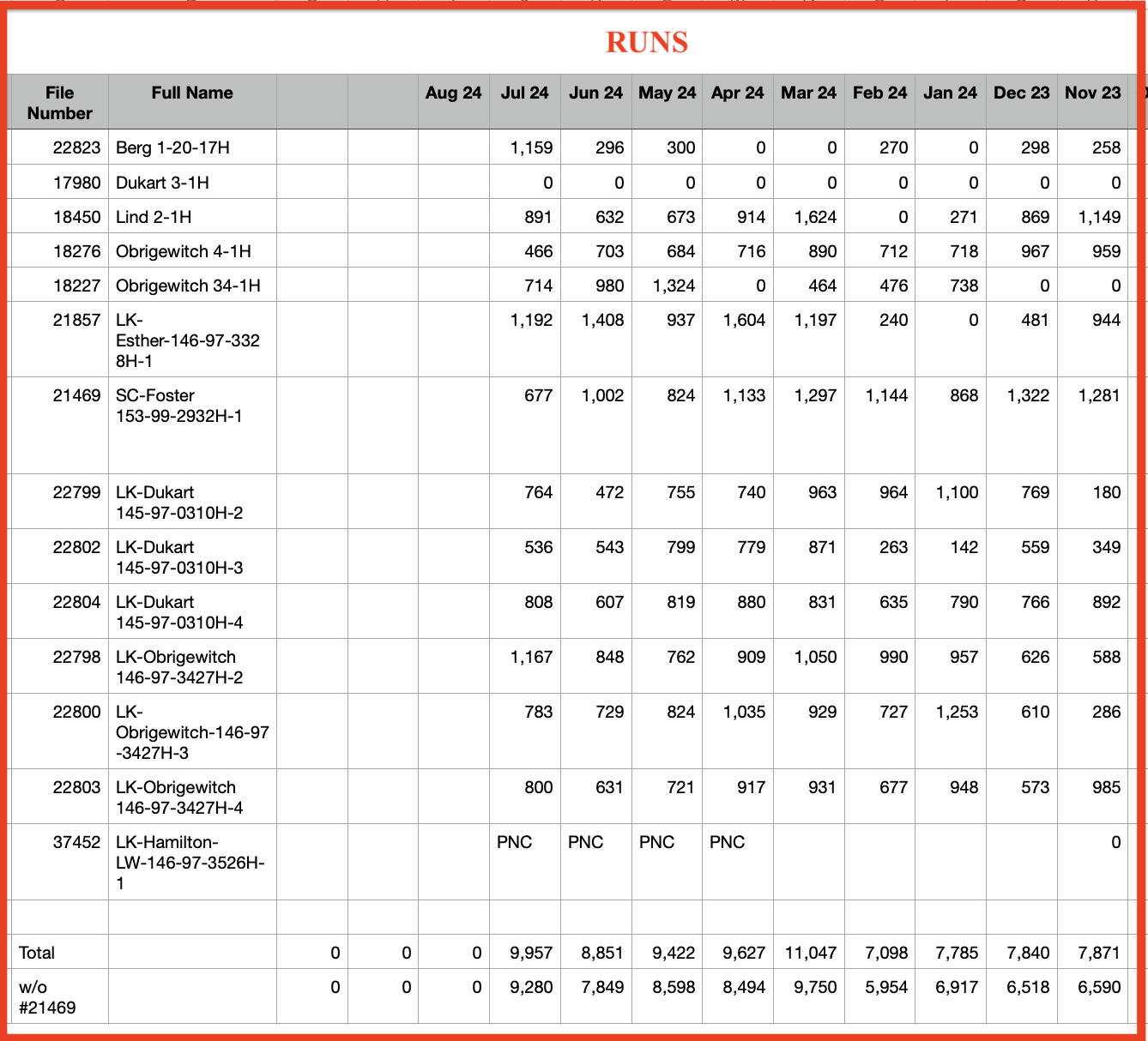
 A reader sent me some of the following and I'm completing the rest.

First, from the reader, from Dunn County, a screenshot of part of a deed; note section 34-146-97:

Now, the NDIC map. The solid red stars note the three sections in which the reader has mineral rights. 

In addition, the four sections designated with black-outlined red stars represent a four-section (2560-acre) drilling unit. That drilling unit includes one section in which the reader holds minerals, section 34. 

The big black arrow, #37452, is the horizontal that runs north along the section line and will pay royalties to those who have minerals in the four sections designated with black-outlined red stars, including the one section "held" by the reader.

Then, we have a screenshot of the permit of interest.

  • NDIC file number: #37452
  • sections: 26 / 27 / 34 / 35 - 146-97

And finally, the scout ticket for this particular well:
 

Hess will drill four LK-Hamilton wells, but only one will "affect" the reader, the line section well, #37452.

Sunday, January 9, 2022

37761, Continental Resources, Harrisbug 2-29HSL -- Part Of Ekke's Portfolio -- January 9, 2022

Updates

January 22, 2022: the NDIC map is now updated and it confirms that the reader has minerals associated with this well, #37761. [Note: #38189 is not relevant to this discussion; the horizontal turns north into Baker oil field, not Indian Hill.]

Original Post

The graphics.

Key:

  • solid red star: Ekke's minerals in this section; section 33-153-101;
  • solid blue star: this section (28-153-101) is the other half of the 1280-acre (two-section) drilling unit
  • the two red/blue stars: the adjacent 1280-acre unit; does not apply to Ekke
  • all four stars make up a 2560-acre (four-section) drilling unit

This graphic is of the general area:

  • the section with the red star: Ekke's mineral rights, the XTO Nelsen State wells are circled
  • the two sections with the red star / solid blue star: the 1280-acre drilling unit for the XTO Nelsen State wells
  • the four sections, all with stars are a 2560-acre (four-secion) drilling unit;

This graphic shows the four-section (2560-acre) drilling unit (all four stars):

  • the solid red star: Ekke's mineral rights/deed
  • the solid blue star + the solid red star: the 1280-acre drilling unit for the XTO Nelsen State wells (circled at the bottom)
  • all four stars: the 2560-acre (four-section) drilling unit that includes the new well, #37661 (circled at the top)

This graphic zooms in all the way; #37661 permit shows that it is in the four-section (2560-acre) drilling unit that includes section 33-153-101 (an Ekke section):

  • 37761, conf, CLR, Harrisburg 2-29HSL, Indian Hill, first production 11/21; t--; cum 28K 11/21;
    • 37761: NDIC file number
    • CLR: Continental Resources
    • Harrisburg 2-29HSL: name of well
    • HSL: 
      • H: horizontal, middle Bakken
      • S: runs south
      • L: line section well, 2560-acre (four-section drilling) unit.

Permit