Wednesday, September 18, 2024

Grayson Mill Wells -- Reader's Question -- September 18, 2024

To the reader:

  • the first thing I would do is go through your most recent production statement and see if you have fourteen (14) wells;

The following was done quickly and there may be typographical errors. 

Your production statement won't show the NDIC file number; it will show the operator's number. But certainly the operator can sort that out.

June 28, 2024 production statement; production through May, 2024 -- note: the CUDA well is now on the production statement:

NDIC file number, name of well, oil field, section-township-range:

19008, Brakken 30-31 1-H, Catwalk oil field, SENE 30-154-100; Williams County;

21907, Shorty 4-9 #1-H, Stony Creek oil field, Lot 2, section 4-155-100; Williams County;

30143, Folvag 5-8 XE 1H, Stony Creek oil field, SESE 32-156-100; Williams County;

31461, Shorty 4-9F #2TFH, Stony Creek oil field, NWNE 4-155-100; Williams County;

31443, Shorty 4-9F #3H, Stony Creek oil field, NWNE 4-155-100; Williams County;

31699, Shorty 4-9F #4TFH, Stony Creek oil field, SWSW 33-156-100; Williams County;

31700, Shorty 4-9F #5H, Stony Creek oil field, SWSW 33-156-100; Williams County;

31701, Shorty 4-9F #6TFH, Stony Creek oil field, SWSW 33-156-100; Williams County;

31702, Shorty 4-9F #7H, Stony Creek oil field, SWSW 33-156-100; Williams County;

31703, Shorty 4-9F #8TFH, Stony Creek oil field, SWSW 33-156-100; Williams County;

39366, Williston 30-31F XE 1H, Catwalk oil field, Lot 4, section 19-154-100; Williams County;

19478, Round Prairie 10-1819H, Round Prairie oil field, NENW 18-154-103; Williams County;

19927, Short Prairie 8-1224H, Round Prairie oil field, SWSE 12-154-104; Williams County;

39756, Cuda 14-26F XE 1H, Round Prairie oil field, SESE 11-154-104; Williams County;

Tuesday, September 17, 2024

Offer -- PCG -- September 17, 2024

A reader sent me this note:

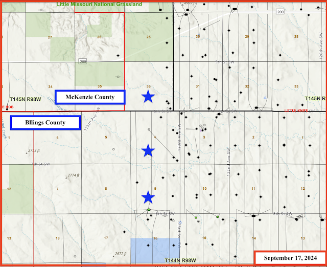
Phoenix Capital Group is offering to lease minerals in McKenzie County, legal description: T145N - R98W - Section 36.  The offer is a bonus of $3000 per nma (net mineral acre) with 20% royalty. 
 
Contact: Malcolm at 720-505-5515 (Denver, time difference).

See this post for the Zabolotny wells. Several maps at that post.

At this site, the two sections in Billings County are noted.

Not noted at that site, is the section to the north in McKenzie County, in which the reader also has minerals. That's the section that PCG is interested in.

Screenshots from the reader's deeds:


The map:


Comments:
  • my hunch: new wells are going to be sited in section 36 (or section 4 to the south) with a spacing unit to be sections 36 and 25 to the north, where there are current no horizontal wells. 

Monday, September 9, 2024

How The Bakken Works -- Why The Bakken Is So Exciting -- Oasis Dishon Well And The Oasis Andrews Federal Well -- September 9, 2024

This is why the Bakken is so exciting for small mom-and-pop mineral owners.

A reader wrote to tell me she has a "new" well. 

It's a long story but shows how the Bakken "works."

The reader has minerals in this section:

  • Williams County
  • Ft Buford Oil Field.
  • Section 31-153-103.
  • Section 31: SE1/4 (SE4)

It just so happens the reader has a small well sited in section 30, running south into section 31. The drilling unit is a 1280-acre unit and that's why she gets royalties for that well:

  • 22475, 761, Oasis, Dishon 1-30H, t3/13; cum 219K 8/19; cum 268K 7/24; still producing about 1,000 bbls/month (8/19); producing about 750 bbls/month (7/24).

Oasis sited the Andrews Federal wells to the west and the reader would have no interest in those wells. 

BUT!

One of the Andrews Federal wells is a section line well that "impacts" sections 30/31-153-103, and thus the reader participates in that Andrews Federal well.  A section line well draws oil from both sides of the section line.

The older well, the Dishon well, is in a 1280-acre spacing unit, a standard two-mile Bakken lateral.

The Andrews Federal well is an extended long lateral well, in a 1920-acre standup spacing unit, and the section line well, as mentioned, impacts the 1280-spacing Dishon unit to the east.

The Andrew Federal ... 4BX (a section line well) is one of six wells on these two three-well pads, but the reader will participate only in the section line well (4BX). 

The maps:

The Andrews Federal well, a section line well:

  • 39910, F/A, Oasis, Andrews Federal 5304 12-24 4BX, Ft. Buford, t4/24; cum 67K 7/24;
PoolDateDaysBBLS OilRunsBBLS WaterMCF ProdMCF SoldVent/Flare
BAKKEN7-2024261875018757433471389213401491
BAKKEN6-20243023330233215084916586134983088
BAKKEN5-2024312259322512509631621715785432
BAKKEN4-202430212620802174142994087212

Equinor -- September 2024

The Equinor - Grayson Mill story is tracked at this post.

In brief:

November 17, 2021: Equinor exited the Bakken in 2021. All Bakken assets transferred to Grayson Mill. For the time being, Equinor will continue paying royalties. 

The reader thinks he/she last received a check from Equinor in October, 2021. After that, no more Equinor checks until September 9 (check dated August 28) for all of the wells of interest at that time:

  • Folvag (1)
  • Brakken (1)
  • Shorty (8)

The August 28, 2024, production statement was 95 pages long, some production data all the way back to 2010.

Monday, September 2, 2024

Petro-Hunt Zabolotny Wells -- An Update -- September 2, 2024

First, the map, posted a long time ago, stars represent the mineral acres owned by Tucker:


Look at 40203. That was a permit on a pad that was projected back in 2023. 
 
More maps:

The maps:


#37987, is a Zabolotny well and has been producing for quite some time. See this post.

  • 37987, loc/A, Petro-Hunt, Zabolotny 144-98-4A-9-1H, Little Knife, t--; cum 234K 7/24; most recent production:
PoolDateDaysBBLS OilRunsBBLS WaterMCF ProdMCF SoldVent/Flare
BAKKEN7-2024232044196516921194919490
BAKKEN6-202419221122115040200620060
BAKKEN5-202431371737068707323932390
BAKKEN4-202430366337638900323532350
BAKKEN3-202431477648039729420742070
BAKKEN2-202429377936489239333033300
BAKKEN1-2024314928505511274435043473
BAKKEN12-2023314702466211060423742370
BAKKEN11-2023304868479312481430643060
BAKKEN10-202331350435868565315031500

Now, the "new" five -well pad:

  • three of those five wells are "State" wells and will run south, not Tucker wells;
  • two of those five wells are Zabolotny wells and are Tucker wells.

The Zabolotny wells on that five-well pad:

  • 40203, conf, Petro-Hunt, Zabolotny 144-98-9C-4-2H, Little Knife, NPD, spud 3/9/24.
  • 40325, loc/A, Petro-Hunt, Zabolotny 144-98-9C-4-3H, Little Knife, NPD, spud 3/11/24.

Both of these wells are coming off confidential list in early September, 2024. So far, no production data has been reported.  They've been spud which suggests (but not definite) they've been drilled to depth. FracFocus does not yet show any data for these two wells. Link here to FracFocus.