Monday, December 9, 2024

Devon -- Grayson Mill -- December 9, 2024

L

Devon in the Bakken: A reader writes that he/she received his/her first check from Devon since the deal with Grayson Mill closed. A quick look by the reader says everything looks correct. 


*******************************
Sharks and Fish: Evolution
 
 
*******************************
Montana: Paleontology

Those following the Bakken are very, very aware of the formations mentioned below. 

In the United States, in Montana:

If you want to study dinosaurs, you go to Hell Creek, eastern Montana.

If you want to study the evolution of fish / sharks, you go to Bear Gulch, Fergus County, near Lewistown, Montana.

The Bear Gulch Limestone is commonly considered to be part of the Heath Formation, the youngest formation in the Big Snowy Group of central Montana. 

Some authors instead consider the Bear Gulch Limestone to be an early member of the Tyler Formation, a patchy but widespread unit of Carboniferous limestone and terrestrial sediments.

Most of the Heath Formation is represented by black shales and marls, indicative of brackish and salty littoral environments. It developed along a transgressive sequence in a narrow saltwater seaway, known as the Central Montana Trough  or Big Snowy Trough. This seaway flowed into the Williston Basin, a shallow inland sea further east. The Central Montana Trough would have also been linked to fully marine basins on the western coastline of Laurussia, but this connection may have been broken by the time of the Bear Gulch Limestone's deposition.

Many distinct limestone lenses (localized sediment packages) are developed in the Heath Formation. They overlap each other in an east-to-west sequence which extends over a distance of 160 km in the Central Montana Trough. The only exposed portions of the sequence are found at Potter Creek Dome, a small uplifted area northeast of the Big Snowy Mountains. The last few limestone lenses form a large portion of the Upper Heath Formation, which is sometimes termed the Bear Gulch Member in recognition of the most well-exposed and fossiliferous lens in the sequence. This lens, the Bear Gulch Limestone, was also one of the last in the sequence, only succeeded by the Surenough Beds immediately west of it.  The Bear Gulch Limestone can be observed in numerous outcrops, spread out over an area of more than 20 square miles in Fergus County, Montana.

The creation of limestone lenses in the Heath Formation has been linked to tectonic activity extending the seaway by excavating bays out of the surrounding land. As old bays are filled in and buried by sediment, faulting and seismic events form new bays in a long eastward to westward succession.  It may have taken a mere 1000 years for the bay responsible for the Bear Gulch Limestone lens to fill in completely, after only 25,000 years for the entire bay formation sequence to run its course across Montana

The final limestone deposits in the area were succeeded by freshwater lake sediments of the Cameron Creek Formation, the oldest unit of the early Pennsylvanian-age Amsden Group.


Friday, November 22, 2024

Chord Energy -- Oasis Dahl Federal -- Five Well Pad With Parent Well Off-Line -- November 22, 2024

The well of interest:

  • 21266, 494, A/AL, Oasis, Dahl E Federal 15-11H, Baker, t5/23; cum 251K 9/24; recent production, nothing in the file report to explain the reason for only one day of production in September, 2024, maps provide no obvious answer:
PoolDateDaysBBLS OilRunsBBLS WaterMCF ProdMCF SoldVent/Flare
BAKKEN9-20241961257295869
BAKKEN8-2024313252324522963166314818
BAKKEN7-2024291984197617031598152672
BAKKEN6-20242926152670206519561664292
BAKKEN5-2024313960394827193105305253
BAKKEN4-20242827472774209037433044
BAKKEN3-20243131353110249260159
BAKKEN2-202429281827992737187201872
BAKKEN1-20243126022603264015393941145
BAKKEN12-20233131393144304321831360823
BAKKEN11-20233041514149498138003388412
BAKKEN10-2023315875587662155737563899

The five-well pad:

  • 38770, F/A, Oasis, Dahl E Federal 5301 13-14 2B, Baker, t1/12; cum 223K 9/24;
  • 21266, 494, Oasis, Dahl E Federal 15-11H, Baker, t5/23; cum 251K 9/24; off line, September, 2024
  • 38771, F/A, Oasis, Dahl E Federal 5301 13-14 3B, Baker, t5/23; cum 268K 9/24;
  • 38772, F/A, Oasis, Dahl E Federal 5301 13-14 4B, Baker, t5/23; cum 270K 9/24;
  • 38773, F/A, Oasis, Dahl E Federal 5301 13-14 5B, Baker, t5/23; cum 251K 9/24;

The maps:


Friday, October 25, 2024

Petro-Hunt Reports Zabolotny Well, #42325, Has Been Completed -- October 25, 2024

The well:
  • 40325, 549, Petro-Hunt, Zabolotny 144098-9C-4-3H, Billings County; at the NDIC, no production data; the well file provides no additional relevant information.

Monday, October 7, 2024

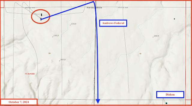
Dishon And Andrews Federal -- Ft Buford -- Chord Energy -- Oasis -- October 7, 2024

Note: in a long note like this, there will be typographical and content errors.

The reader has interests in this location: section 31-153-103. A screenshot of part of the deed:

The reader has been receiving royalties from this well for quite some time:

  • 22475, 761, Oasis/SM Energy, Dishon 1-30H, Ft Buford t3/13; cum 269K 8/24;
  • the Dishon well is  sited in section 30 with bottom hole in section 31; 1280-acre spacing, sections 30 / 31 - 153 - 103

Recently the reader noted that she was receiving royalties from a new well:

  • 39910, F/A, Oasis, Andrews Federal 5301 12-24 4 BX, Ft Buford, t4/24, cum 90K 8/24.  
  • This well is on a six-well pad, three horizontals running north and three Andrews Federal horizontals running south. These are extended long-lateral horizontals, three-section laterals or three-mile long horizontals; two of these south-running horizontals are three-section spacing (1920-acre spacing) but it just so happens that the Andrews Federal ... 4BX well (#39910) is a section line well and the spacing unit is six sections:

Note that one of the six sections, 31-153-103 is the section in which the reader has minerals, and is also the section in which is located the bottom hole of the Dishon well.

Production from this section-line well, #39910:

PoolDateDaysBBLS OilRunsBBLS WaterMCF ProdMCF SoldVent/Flare
BAKKEN8-2024312301422893513431744016888552
BAKKEN7-2024261875018757433471389213401491
BAKKEN6-20243023330233215084916586134983088
BAKKEN5-2024312259322512509631621715785432
BAKKEN4-202430212620802174142994087212

So, again, #39910, the Andrews Federal well is sited almost a mile away from the Dishon well, in section 24, with the bottom hole in section 31 (two different townships); the horizontal runs south along the section section line; the spacing unit is a six-section spacing unit, encompassing sections 19 / 24 / 30 / 29 / 31 / 36.

The Dishon well is a two-section, two-mile extended lateral (two-section spacing).

The Andrews Federal well is a three-section, three-mile extended lateral (six-section spacing).

See maps below.


The typical spacing unit in the Bakken, is two sections, or 1280 acres. 

If one owns 40 acres in a 1280-acre spacing unit, and the lease is for 20% of the oil sold, the "decimal" would be:

  • (40/1280) x 0.2 = 0.00625

However, in a 3840-acre spacing unit, (six-section spacing unit), the "decimal" would be

  • (40/3840) x 0.2 = 40 = 0.00208

The reader says her decimal is 0.00004566, according to her production statement.

Some folks own as little as one acre in any given spacing unit. What would be the decimal point for owning one acre in a 1280-acre spacing unit compared to a 3840-acre spacing unit, each unit with the same 20% royalty rate:

  • (1/1280) x 0.2 =  0.00015625
  • (1/3840) x 0.2 = 0.00005208

At 18%?

  • (1/1280) x 0.18 =  0.000140625
  • (1/3840) x 0.18 = 0.000046875

Going one step further: if the well produced 10,000 bbls in that month and the selling price was $75, then:

  • $75 / bbl x 0.00015625 x 10,000  bbls = $117 vs
  • $75 / bbl x 0.00005208 x 10,000 bbls = $39.

The reader says she was paid about $66 the oil from that well recently (in a monthly statement) and the price of oil sold was $74.03. So, everything sort of adds up -- at least in the "ballpark" as they say. 

Disclaimer: I often make simple arithmetic errors, and much of the above was based on conjecture, assumptions, and estimates

Saturday, October 5, 2024

Petro-Hunt Wells Updated For Reader -- Production Statement Dated September 25, 2024

October 24, 2024: 

The well:

  • 40325, 549, Petro-Hunt, Zabolotny 144098-9C-4-3H, Billings County; at the NDIC, no production data; the well file provides no additional relevant information.

Original Post

Petro-Hunt production and wells update.

Reader's monthly production statement, dated September 25, 2024: all wells accounted for; all wells still producing with exception of one:

  • 32165, 1,090, Petro-Hunt, USA 153-95-34C-14-4H, Charlson, t5/18; cum 523K 7/24; off line 8/24. No production in August, 2024.

This well is off line because the neighboring well is being completed:

  • 38359, conf, Petro-Hunt, Sherven Trust 153-95-27A-26-1HS, Charlson, 

In addition to this well which is yet to begin production, the reader is watching these two Petro-Hnt wells. According to the well files, both wells have been drilled to depth and are waiting completion.

  • 40203, conf/drl, Petro-Hunt, Zabolotny 144-98-9C-4-2H, Little Knife, 1280-acre spacing, sections 4 / 9 - 144-98.
  • 40325, conf/drl, Petro-Hunt, Zabolotny 144-98-9C-4-3H, Little Knife, 1280-acre spacing, sections 4 / 9 - 144-98.

Thursday, October 3, 2024

Petro-Hunt -- Production Statements -- Price Paid For Oil, Natural Gas, Plant Products

Dated: 9/30/2024

Only one well (date / product / price) --

Guadalupe 11-23H

  • 1/22  Price change correction minus


COP -- Production Statements -- Price Paid For Oil, Natural Gas, Plant Products

Dated: 9/30/2024

Only one well (date / product / price) --

Guadalupe 11-23H

  • 1/22  Price change correction minus
  • 8/23  MCF    1.990
  • 9/23 MCF 1.4799
  • 10/23
  • 11/23
  • 12/23
  • 1/24
  • 2/24
  • 3/24
  • 4/24
  • 5/24
  • 6/24
  • 7/24 MCF 1.9972


  • 1/22 Price change correction positive
  • 4/22 gallons 0.6760
  • 8/23 gallons 0.3585
  • 10/23 gallons 0.3604
  • 11/23 gallons 0.3372
  • 12/23
  • 1/24
  • 2/24
  • 3/24
  • 4/24
  • 5/24
  • 6/24
  • 7/24 0.4219


  • 1/22 price change correction negative
  • 8/23 gallons 1.8006
  • 9/23 gallons 1.9802
  • 10/23 gallons 1.8836
  • 11/23 gallons 0.6786
  • 12/23
  • 1/24
  • 2/24
  • 3/24
  • 4/24
  • 5/24
  • 6/24 gallons 1.660
  • 7/24 gallons 1.7074


  • 8/22 Price change slight positive 
  • 1/23. bbls 0.00
  • 9/23 bbls $89.8292
  • 10/23 bbls. $85.2174
  • 11/23 bbls $76.6545
  • 12/23
  • 1/24
  • 2/24
  • 3/24
  • 4/24
  • 5/24
  • 6/24 bbls $73.0328


Wednesday, October 2, 2024

XTO -- Production Statements -- Price Paid For Oil, Natural Gas, Plant Products

Dated: 9/25/2024

Multiple wells (date / product / price) -- months 7/24 and 8/24 for all wells; varies; prices vary;

Arnold 21X-17BXC:     6/24; oil; statutory interest: $0.05
Arnold 21X-17BXC:     7/24; gas; $4.11
Arnold 21X-17BXC:     7/24; oil; $80.26;
Arnold 21X-17G:          7/24; gas; $4.26;
Arnold 21X-17G:         7/24; oil; $80.26;
Arnold 21X-17F:         7/24; gas; $4.13;
Arnold 21x-17F:         7/24; oil; $80.26;
Hanson 11-12H
Hanson 11-12H
Hanson 11-12H
Hanson 11-12H
Hanson 11-12B
Hanson 11X-12B
Hanson 11X-12B
Hanson 11X-12B
Hanson 11X-12E
Hanson 11X-12E
Hanson 11X-12E
Hanson 11X-12A
Hanson 11X-12A
Hanson 11X-12A
Hanson 11X-12A
Gilbertson 11-26H
Gilbertson 11-26H
Gilbertson 11-26H
Gilbertson 11-26H
Gilbertson 34-26NEH
Gilbertson 34-26NEH
Gilbertson 34-26NEH
Gilbertson 34-26NEH
Bergem 44-28NWH,
Bergem 44-28 NWH
Tobacco Garden 31-29 NEH
Botacco Garden 31-29NEH
Lawlar 41-15 SEH
Lwlar 51-15 SEH
Lawlar 41-15 SH
Lawlar 41-15 SH
Leiseth 24X-22E
Leiseth 24X-22E
Leiseth 24X-22F
Leiseth 24X-22F
Stenberg 14-10 SWH
Stenberg 14-10 SWH
Stenberg 14-10 SEH
Stenberg 14-10 SEH
Gilbertson 11X-26FXG
Gilberton 11X-26FXG
Gilbertson 11X-36FXG
Gilbertson11X-26FXG
Gilbertson 11X-26B
Gilbertson 11X-26B
Gilbertson 11X-26B
Gilbertson 11X-26B
Gilbertson 11X-26F
Gilbertson 11X-26F
Gilbertson 11X-26F
Gilbertson 11X-26F
Gilbertson 34X-26BXC
Gilbertson 34X-26BX
Gilbertson 34X-26BXC
Gilbertson e4X-26BXC
Gilbertson34X-26G
Gilbertson 34X-26G
Gilbertson 34X-26G
Tobacco Garden 11X-17A
Tobacco Garden 11X-17A: 7/24; oil; $802.26;
Tobacco Garden 11X-17E: 12/20; oil; price change $0.01
Tobacco Garden 11X-17E: 7/24; gas; $3.25;
Tobacco Garden 11X-17E: 724; oil; $80.25;
Toabacco Garden 11X-17B: 7/24; gas; $3.60;
Tobacco Garden 11X-17B: 7/24; oil; $80.26;
Arnold 21X-17H: 7/24; gas; $4.21;
Arnold 21X-17H: 7/24; oil; $80.26;


Tuesday, October 1, 2024

CLR -- Production Statements -- Price Paid For Oil, Natural Gas, Plant Products

Dated: 9/25/2024

Multiple wells (date / product / price) -- months 7/24 and 8/24 for all wells; varies; prices vary;

  • 1 Earl 1-24H: 7/24; G; $3.15
    • Earl 1-24H: 7/24; O; $77.50
  • 2 Earl 2-25H: 
    • Earl 2-25H: 8/24; O; $73.33
  • 3 McKenzie 1-34H
  • 4 Bud 1-19H
  • 5 Todd 1-6H
  • 6 Memphis 2-4H
  • 7 Earl 3-25H
  • 8 Anna 1-27H
  • 9 Earl-Reimann 4 HSU
  • 10 Earl-Rita HSU
  • 11 Morgan 1-29H1
  • 12 Bud 3-30H1
  • 13 Alfsvaag 2-31H
  • 14 Bud 2-30H
  • 15 Alfsvaag 4-31H
  • 16 Alfsvaag 5-31H1
  • 17 Bud 4-30H
  • 18 Bud 5-30H1
  • 19 Anna 2-34H
  • 20 Anna 4-34H1
  • 21 Anna 5-34H
  • 22 Anna 8-34H1
  • 23 Anna 7-34H
  • 24 Anna 6-34H1
    • Anna 6-34H1
  • 25 Harrisburg 2-27HSL

Sunday, September 29, 2024

North Tobacco Garden

See this post.

  • Parcel 1022 -- 151-99-15; huge, XTO, North Tobacco Garden, the Lawlar wells; along with 22, a 1280-acre unit
  • Parcel 1023 --  151-99-20 -- XTO Tobacco Garden / Arnold wells
  • Parcel 1024 -- 151-99-21, nothing; could be huge, Tobacco Garden;
  • Parcel 1025 -- 151-99-22, huge, XTO, North Tobacco Garden, the Lawlar wells; along with 15, a 1280-acre unit

The map:


Hess -- Production Statements -- Price Paid For Oil, Natural Gas, Plant Products


Dated: 9/25/2024

One well:

  • SC Foster-153-99-2932H-1, Williams County

Entries (date / product code / price):

  • 7/22: 204: $6.63
  • 7/22: 400: $0.83
  • 8/22: 204: $8.04
  • 8/22: 400: $0.00
  • 6/24: 204: $1.40
  • 6/24: 400: $0.39
  • 6/24: 40F: $1.48
  • 7/24: 100: $81.08
  • 7/24: 204: $1.38
  • 7/24: 400: $0.43
  • 7/24: 40F: $1.51
  • 8/24: 100: $78.57
  • 7/22: 204: $6.83
  • 7/22: 400: $0.83
  • 8/22: 204: $8.04
  • 8/22: 400: $0.00
  • 6/24: 204: $1.40
  • 6/24: 400: $0.39
  • 6/24: 40F: $1.48
  • 7/24: 100: $81.08
  • 7/24: 204: $1.38
  • 7/24: 400: $0.43
  • 7/24: 40F: $1.51
  • 8/24: 100: $76.57

Explanation of codes: Product Type --

  • 1XX (100): oil (in bbls) -- price per bbl
  • 2XX (204): gas -- dry (MCF) -- price per MCF
  • 3XX (---): condensate -- price per bbl
  • 4XX (400): plant products -- price per gallon
  • 4XX (40F): ??? -- price per gallon --  I do not know what 40F is --
    • but it is a plant product --a by-product from the oil that is produced and that Hess produces on-site; a google search was not helpful. My hunch: ethane


Wednesday, September 25, 2024

Counting Eggs Before They Hatch -- September 25, 2024

Zabolotny: Little Knife, three wells in the Zabolotny area.

Lind wells, six.

Alfsvaag / Bud wells: six.

  • September, 2024: rig on pad


Offers -- 2024

Phoenix Capital Group

  • Montana: 024045 (need to confirm)
    • August, 2024
  • North Dakota: 14509836 -- 
    • September, 2024; Zabolotny area;

Sunday, September 22, 2024

Enerplus Wells That Are Producers And May Be Producers For The Reader -- September 22, 2024

From a sidebar discussion with a reader.  The reader should be seeing a number of new Lind wells and a section line Hamilton well or two.

From the reader's deeds:

  • sections 3 / 4 / 6 / 11 - 145-97 (Lind, Obrigewitch, Dukart)
  • sections 31 / 33 / 34 - 146-97 (Dolezal, Obrigewitch)


I'm particularly interested in the wells inside the circle below. These wells are all still confidential, I believe:

The map


The wells of interest, zoom in:

The wells --

  • the wells with NDIC file numbers in bold red are producing for the reader --
  • the Lind wells with NDIC file numbers in bold black are still confidential, but based on location and names of wells, may be producers for the reader --
  • 21857, Enerplus, LK-Esther-146-97-3328H-1, SESW 33-146-97,
  • 18276, Enerplus, Obrigewitch 4-1H, Lot 3 4-145-97,
  • 18227, Enerplus, Obrigewith 34-1H, SESW 34-146-97,


  • 17980, Enerplus, Dukart 3-1H, NENW 3-145-97;


  • 22804, Enerplus, LK-Dukart 145-97-0310H-4, SWSE 34-146-97;
  • 22802, Enerplus, LK-Dukart 145-97-0310H-3, SWSE 34-146-97;


  • 22800, Enerplus, LK-Obrigewitch 146-97-3427H-3, SWSE 34-146-97,

Ten-well pad that is confidential. #37452 was PNC'd but on the production statements for the reader suggest that the Lind wells could be producers for the reader.

  • 40999, Enerplus, Lind 145-97-2-11-8H, Lot 4 2-145-97; spacing unit 2 / 11 - 145-97
  • 41100, Enerplus, Lind 145-97-2-11-7H, Lot 4 2-145-97;
  • 41097, Enerplus, Lind 145-97-2-11-6H, Lot 4 2-145-97;
  • 41096, Enerplus, Lind 145-97-2-11-5H, Lot 4 2-145-97;
  • 41095, Enerplus, Lind 145-97-2-11-4H, Lot 4 2-145-97;
  • 41094, Enerplus, Lind 145-97-2-11-3H, Lot 4 2-145-97; spacing unit 2 / 11 - 145-97
  • 41093, Enerplus, Lind 145-97-2-11-2H-WLL, Lot 4 2-145-97; spacing unit 2 / 3 / 10 / 11 - 145 - 87
  • 37454 PNC/LOC, Enerplus, LK-Hamilton-146-97-3526H-5, Lot 2 2-145-97; spacing unit 26 / 35 -146-97 (NO)
  • 37453, PNC/LOC, Enerplus, LK-Hamilton-146-97-3526H-6, Lot 4 2-145-97; spacing unit 26 / 35 -146-97 (NO)
  • 37452, PNC/LOC, Enerplus, LK-Hamilton-LW-146-97-3526H-1, Lot 2 2-145-97; spacing unit 26 / 27 / 34 / 35 -146-97 (YES)


  • 41103, Enerplus, Hamilton 146-97-35-26-7H, Lot 4 2-145-97; spacing unit 26 / 35 -146-97 (NO)
  • 41102, Enerplus, Hamilton 146-97-35-26-6H, Lot 4 2-145-97; spacing unit 26 / 35 -146-97 (NO)
  • 41101, Enerplus, Hamilton 146-97-35-26-5H, Lot 4 2-145-97; spacing unit 26 / 35 -146-97 (NO)
  • 41098, Enerplus, Hamilton 146-97-35-26-4H-WLL, Lot 4 2-145-97; spacing unit 26 / 27 / 34 / 35 -146-97 (YES)


  • 22479, Enerplus, LK-Hamilton 146-97-3526H-3, SWSE 35-146-97; spacing unit 26 / 35 -146-97 (NO)
  • 22480, Enerplus, LK-Hamilton 146-97-3526H-2, SWSE 35-146-97; spacing unit 26 / 35 -146-97 (NO)
  • 17644, Enerpluis, Hamilton 35-1H, Little Knife, SWSE 35-146-97; spacing unit 26 / 35 -146-97 (NO)
  • 18450, Enerplus, Lind 2-1H, Little Knife, NWNE 2-145-97,


The Lind wells:

  • 18450, 1,049, Enerplus, Lind 2-1H, Little Knife, NWNE 2-145-97, t5/10; cum 232K 7/24; closed hole, 2,257,119 lbs proppant; 43,869 bbls = 1,754,740 million gallons of water. Spacing unit: all of sections 2 / 11 - 145-97.

Wednesday, September 18, 2024

Grayson Mill Wells -- Reader's Question -- September 18, 2024

To the reader:

  • the first thing I would do is go through your most recent production statement and see if you have fourteen (14) wells;

The following was done quickly and there may be typographical errors. 

Your production statement won't show the NDIC file number; it will show the operator's number. But certainly the operator can sort that out.

June 28, 2024 production statement; production through May, 2024 -- note: the CUDA well is now on the production statement:

NDIC file number, name of well, oil field, section-township-range:

19008, Brakken 30-31 1-H, Catwalk oil field, SENE 30-154-100; Williams County;

21907, Shorty 4-9 #1-H, Stony Creek oil field, Lot 2, section 4-155-100; Williams County;

30143, Folvag 5-8 XE 1H, Stony Creek oil field, SESE 32-156-100; Williams County;

31461, Shorty 4-9F #2TFH, Stony Creek oil field, NWNE 4-155-100; Williams County;

31443, Shorty 4-9F #3H, Stony Creek oil field, NWNE 4-155-100; Williams County;

31699, Shorty 4-9F #4TFH, Stony Creek oil field, SWSW 33-156-100; Williams County;

31700, Shorty 4-9F #5H, Stony Creek oil field, SWSW 33-156-100; Williams County;

31701, Shorty 4-9F #6TFH, Stony Creek oil field, SWSW 33-156-100; Williams County;

31702, Shorty 4-9F #7H, Stony Creek oil field, SWSW 33-156-100; Williams County;

31703, Shorty 4-9F #8TFH, Stony Creek oil field, SWSW 33-156-100; Williams County;

39366, Williston 30-31F XE 1H, Catwalk oil field, Lot 4, section 19-154-100; Williams County;

19478, Round Prairie 10-1819H, Round Prairie oil field, NENW 18-154-103; Williams County;

19927, Short Prairie 8-1224H, Round Prairie oil field, SWSE 12-154-104; Williams County;

39756, Cuda 14-26F XE 1H, Round Prairie oil field, SESE 11-154-104; Williams County;

Tuesday, September 17, 2024

Offer -- PCG -- September 17, 2024

A reader sent me this note:

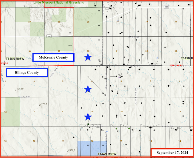
Phoenix Capital Group is offering to lease minerals in McKenzie County, legal description: T145N - R98W - Section 36.  The offer is a bonus of $3000 per nma (net mineral acre) with 20% royalty. 
 
Contact: Malcolm at 720-505-5515 (Denver, time difference).

See this post for the Zabolotny wells. Several maps at that post.

At this site, the two sections in Billings County are noted.

Not noted at that site, is the section to the north in McKenzie County, in which the reader also has minerals. That's the section that PCG is interested in.

Screenshots from the reader's deeds:


The map:


Comments:
  • my hunch: new wells are going to be sited in section 36 (or section 4 to the south) with a spacing unit to be sections 36 and 25 to the north, where there are current no horizontal wells. 

Monday, September 9, 2024

How The Bakken Works -- Why The Bakken Is So Exciting -- Oasis Dishon Well And The Oasis Andrews Federal Well -- September 9, 2024

This is why the Bakken is so exciting for small mom-and-pop mineral owners.

A reader wrote to tell me she has a "new" well. 

It's a long story but shows how the Bakken "works."

The reader has minerals in this section:

  • Williams County
  • Ft Buford Oil Field.
  • Section 31-153-103.
  • Section 31: SE1/4 (SE4)

It just so happens the reader has a small well sited in section 30, running south into section 31. The drilling unit is a 1280-acre unit and that's why she gets royalties for that well:

  • 22475, 761, Oasis, Dishon 1-30H, t3/13; cum 219K 8/19; cum 268K 7/24; still producing about 1,000 bbls/month (8/19); producing about 750 bbls/month (7/24).

Oasis sited the Andrews Federal wells to the west and the reader would have no interest in those wells. 

BUT!

One of the Andrews Federal wells is a section line well that "impacts" sections 30/31-153-103, and thus the reader participates in that Andrews Federal well.  A section line well draws oil from both sides of the section line.

The older well, the Dishon well, is in a 1280-acre spacing unit, a standard two-mile Bakken lateral.

The Andrews Federal well is an extended long lateral well, in a 1920-acre standup spacing unit, and the section line well, as mentioned, impacts the 1280-spacing Dishon unit to the east.

The Andrew Federal ... 4BX (a section line well) is one of six wells on these two three-well pads, but the reader will participate only in the section line well (4BX). 

The maps:

The Andrews Federal well, a section line well:

  • 39910, F/A, Oasis, Andrews Federal 5304 12-24 4BX, Ft. Buford, t4/24; cum 67K 7/24;
PoolDateDaysBBLS OilRunsBBLS WaterMCF ProdMCF SoldVent/Flare
BAKKEN7-2024261875018757433471389213401491
BAKKEN6-20243023330233215084916586134983088
BAKKEN5-2024312259322512509631621715785432
BAKKEN4-202430212620802174142994087212

Equinor -- September 2024

The Equinor - Grayson Mill story is tracked at this post.

In brief:

November 17, 2021: Equinor exited the Bakken in 2021. All Bakken assets transferred to Grayson Mill. For the time being, Equinor will continue paying royalties. 

The reader thinks he/she last received a check from Equinor in October, 2021. After that, no more Equinor checks until September 9 (check dated August 28) for all of the wells of interest at that time:

  • Folvag (1)
  • Brakken (1)
  • Shorty (8)

The August 28, 2024, production statement was 95 pages long, some production data all the way back to 2010.

Monday, September 2, 2024

Petro-Hunt Zabolotny Wells -- An Update -- September 2, 2024

First, the map, posted a long time ago, stars represent the mineral acres owned by Tucker:


Look at 40203. That was a permit on a pad that was projected back in 2023. 
 
More maps:

The maps:


#37987, is a Zabolotny well and has been producing for quite some time. See this post.

  • 37987, loc/A, Petro-Hunt, Zabolotny 144-98-4A-9-1H, Little Knife, t--; cum 234K 7/24; most recent production:
PoolDateDaysBBLS OilRunsBBLS WaterMCF ProdMCF SoldVent/Flare
BAKKEN7-2024232044196516921194919490
BAKKEN6-202419221122115040200620060
BAKKEN5-202431371737068707323932390
BAKKEN4-202430366337638900323532350
BAKKEN3-202431477648039729420742070
BAKKEN2-202429377936489239333033300
BAKKEN1-2024314928505511274435043473
BAKKEN12-2023314702466211060423742370
BAKKEN11-2023304868479312481430643060
BAKKEN10-202331350435868565315031500

Now, the "new" five -well pad:

  • three of those five wells are "State" wells and will run south, not Tucker wells;
  • two of those five wells are Zabolotny wells and are Tucker wells.

The Zabolotny wells on that five-well pad:

  • 40203, conf, Petro-Hunt, Zabolotny 144-98-9C-4-2H, Little Knife, NPD, spud 3/9/24.
  • 40325, loc/A, Petro-Hunt, Zabolotny 144-98-9C-4-3H, Little Knife, NPD, spud 3/11/24.

Both of these wells are coming off confidential list in early September, 2024. So far, no production data has been reported.  They've been spud which suggests (but not definite) they've been drilled to depth. FracFocus does not yet show any data for these two wells. Link here to FracFocus.

Saturday, August 10, 2024

Production -- CLR Wells


As of August 10, 2024:

File Number

Name — RUNs


July 24

June 24

May 24

Apr 24

Mar 24

Feb 24

Jan 24

Dec 23

Nov 23

Oct 23

Sept 23


Earl 1-24H


Earl 2-25H


McKenzie 1-34H


19424

Bud 1-19H


299

620

600

585

326

587

563

619

545

546

21692

Todd 1-6H


873

613

602

591

552

584

935

788

508

583

23714

Memphis 2-4H


1188

933

1533

1164

845

1252

1373

1097

1104

1640


Earl 3-25H


23279

Anna 1-27H


728

981

915

746

959

487

460

967

726

945


Earl-Reimann 4 HSU


Earl-Rita HSU


26123

Morgan 1-29H1


911

976

805

969

735

714

969

723

718

7008

28937

Bud 3-30H1


955

857

1193

903

858

899

1154

883

954

1126

28935

Alfsvaag 3-31H1


AB


AB


AB

28936

Alfsvaag 2-31H


2377

2407

2047

2409

884

2065

2096

2032

2004

2114

28938

Bud 2-30H


611

1207

941

1202

1180

1256

1483

1410

1195

1450

30237

Alfsvaag 4-31H


869

1184

865

913

1145

851

923

568

849

1283

30238

Alfsvaag 5-31H1


1920

2041

1998

1732

2000

2031

2351

2030

2348

2659

30239

Bud 4-30H


887

856

614

860

541

501

556

803

536

783

30240

Bud 5-30H1


1520

1714

1827

950

1439

916

1405

883

1150

1363

30154

Anna 2-34H


174

195

124

209

421

543

230

427

873

395

30155

Anna 3-34H


32

84

83

124

157

207

162

248

458

385

30156

Anna 4-34H1


201

272

349

397

334

449

435

386

486

532

30157

Anna 5-34H


1838

1888

1306

1107

759

1576

1737

1445

1889

2148

32968

Anna 8-34H1


501

543

719

931

500

437

88

19

193

551

32967

Anna 7-34H


50

0

0

0

0

0

5

26

35

0

32966

Anna 6-34H1


966

1145

1027

1114

760

996

1271

1221

1191

933

32969

Anna 9-34H1


IA

IA

IA

IA

0

0

2

34

208

267

37661

Harrisburg 2-27HSL (4-section)


3083

2965

3302

3248

2993

3917

4084

4097

1073

7903

9718

Bratlien 5 14-27


AB


AB


AB


TOTAL


0

0

0

19,983

21,481

20,850

20,154

17,388

20,268

22,282

20,706

19,043

34,614